![]()
|
|||||||||
|
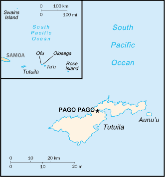
American Samoa
Map Courtesy CIA World Factbook
American Samoa is an unorganized, unincorporated territory of the United States in the South Pacific Ocean, to the East of the larger state of Samoa. Originally inhabited as early as 1000 BC, Samoa was reached by European explorers in the 18th century. International rivalries in the latter half of the 19th century were settled by an 1899 treaty in which Germany and the US divided the Samoan archipelago. The US formally occupied its portion — a smaller group of eastern islands with the noted harbor of Pago Pago — the following year. (see History of Samoa for more.) The western islands are now the independent state of Samoa. The US Navy building a coaling station in Pago Pago Bay for its Pacific Squadron, appointed a local Secretary and secured a Deed of Cession of Tutuila in 1900 and a Deed of Cession of Manu'a in 1904. During World War II, US Marines in American Samoa, outnumbering the local population, had a huge cultural influence. After World War II, a US Department of Interior attempt in Congress to pass Organic Act 4500 to incorporate American Samoa, was defeated through the efforts of American Samoan chiefs led by Tuiasosopo Mariota, and these chiefs efforts led to the creation of a local legislature, the American Samoa Fono. In time the Naval appointed Governor was replaced by a locally elected Governor. Although technically considered "unorganized" in that the US Congress has not passed an Organic Act for the territory, American Samoa is self-governing under a constitution that became effective on July 1, 1967. The US Territory of American Samoa is on the United Nations list of Non-Self-Governing Territories, a listing which is disputed by the country. This article is licensed under the GNU Free Documentation License. It uses material from the Wikipedia article "American Samoa". |